Quick note:
this is a relatively special one for me as this is the one that got me into urban exploration.
HISTORY
The Croxley Green Branch Line was opened in 1912 by the London and North Western Railway and was a part of the Watford and Rickmansworth Railway.
The Stations on the branch line were:
Croxley Green (Terminus)
Watford West
Watford Stadium
The branch line was originally scheduled for closure under the 'Beeching Report' however this was refused and the line continued to serve passengers beyond the 1960s.
Eventually, the branch line was closed in March 1996 when the dual carriageway at Ascot Road was built as it severed the line meaning Croxley Green station was isolated with a motorway cutting through the line.
A temporary bus service was implemented as it was intended to reinstate the railway service once work was complete which was expected to be about 9 months.
From 1996 to 2001 the line was technically just sitting there with nothing going on until in March 2001 the Strategic Rail Authority in collaboration with Railtrack and Silverlink Trains (soon to be London Overground) submitted a proposal to officially close the line which happened in November 2002.
In September 2005 all points, signals and trackside equipment was removed from the line including the junction at Watford High Street, however all the track, stations and bridges remained in anticipation of the Croxley Rail Link.
The Croxley Rail Link was a construction project that would of seen the Metropolitan Line divert from Croxley to Watford Junction taking it along the former branch line from the severed part of Ascot Road to Watford Junction.
The stations constructed would of been:
Cassiobridge (joining the line where Ascot Road Severed the line)
Watford Vicarage Road which would of replaced Watford West and Watford Stadium Stations
before joining the London Overground at Watford High Street.
For more info on how this would of looked I recommend this video:
This project never happened due to complications with funding meaning the line is still intact today.
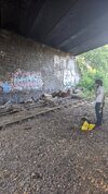
I accessed the line via an old construction access point at Thomas Sawyer Way as for a short time during 2014 the line was being cleared for construction to begin, sadly the track here had been lifted however they resurface heading in both directions, you can probably see the head of the track in this pic.

Heading towards Watford High Street station takes you as far as Wiggenhall Road. It is unsafe to go any further out the bushes as beyond the bridge there is a live railway with trains that are in view. Enough with the talk. Enjoy some pics
Wiggenhall Rd Bridge / Watford High Street Junction
Now heading in the direction of Croxley Green we cross a bridge which takes us over the River Colne and is where we see the first whole bit of track.
This is also where the line to Rickmansworth Church Street diverges with its twin bridge seen to the side.

From this point the shrubbery which consumed the line can really be irritating as you squeeze through it.
Watford Stadium Station:
From this point onwards, the greenery cleared up meaning I got the 'money shot' as we approached Watford West Stn
Watford West Station:
As you can see, Watford West is mostly consumed by bushes but the lamp posts, mirror posts and track are still in place.
Ontowards Croxley:
As we can see in the photo on the right, the AWS Magnet Ramps are still present on the railway.
An AWS ramp lets drivers know about the next signal aspect.
NOTE: After Watford West there is a tree that had fallen onto the line from a nearby school, to proceed you must climb this tree
Google Maps Image:

After this point you get to Ascot Road where you have to slide down the Embankment and cross Ascot Road in order to get back onto path, in order to get to Croxley Green station you must continue by footpath as the line over the bridge is locked off.
I'll be honest here and say I didn't get any photos, however here is one I took from September 2019.
If anyone has managed to access the railway bridge or have better photos of Croxley Green station feel free to throw them in!
I plan to explore this railway yet again one day in the future as there is no planning regarding this line considering CoVID meant the Croxley Rail Link project is near impossible to reinstate
Thank you for reading!
this is a relatively special one for me as this is the one that got me into urban exploration.
HISTORY
The Croxley Green Branch Line was opened in 1912 by the London and North Western Railway and was a part of the Watford and Rickmansworth Railway.
The Stations on the branch line were:
Croxley Green (Terminus)
Watford West
Watford Stadium
The branch line was originally scheduled for closure under the 'Beeching Report' however this was refused and the line continued to serve passengers beyond the 1960s.
Eventually, the branch line was closed in March 1996 when the dual carriageway at Ascot Road was built as it severed the line meaning Croxley Green station was isolated with a motorway cutting through the line.
A temporary bus service was implemented as it was intended to reinstate the railway service once work was complete which was expected to be about 9 months.
From 1996 to 2001 the line was technically just sitting there with nothing going on until in March 2001 the Strategic Rail Authority in collaboration with Railtrack and Silverlink Trains (soon to be London Overground) submitted a proposal to officially close the line which happened in November 2002.
In September 2005 all points, signals and trackside equipment was removed from the line including the junction at Watford High Street, however all the track, stations and bridges remained in anticipation of the Croxley Rail Link.
The Croxley Rail Link was a construction project that would of seen the Metropolitan Line divert from Croxley to Watford Junction taking it along the former branch line from the severed part of Ascot Road to Watford Junction.
The stations constructed would of been:
Cassiobridge (joining the line where Ascot Road Severed the line)
Watford Vicarage Road which would of replaced Watford West and Watford Stadium Stations
before joining the London Overground at Watford High Street.
For more info on how this would of looked I recommend this video:
This project never happened due to complications with funding meaning the line is still intact today.
I accessed the line via an old construction access point at Thomas Sawyer Way as for a short time during 2014 the line was being cleared for construction to begin, sadly the track here had been lifted however they resurface heading in both directions, you can probably see the head of the track in this pic.
Heading towards Watford High Street station takes you as far as Wiggenhall Road. It is unsafe to go any further out the bushes as beyond the bridge there is a live railway with trains that are in view. Enough with the talk. Enjoy some pics
Wiggenhall Rd Bridge / Watford High Street Junction
Now heading in the direction of Croxley Green we cross a bridge which takes us over the River Colne and is where we see the first whole bit of track.
This is also where the line to Rickmansworth Church Street diverges with its twin bridge seen to the side.
From this point the shrubbery which consumed the line can really be irritating as you squeeze through it.
Watford Stadium Station:
From this point onwards, the greenery cleared up meaning I got the 'money shot' as we approached Watford West Stn
Watford West Station:
As you can see, Watford West is mostly consumed by bushes but the lamp posts, mirror posts and track are still in place.
Ontowards Croxley:
As we can see in the photo on the right, the AWS Magnet Ramps are still present on the railway.
An AWS ramp lets drivers know about the next signal aspect.
NOTE: After Watford West there is a tree that had fallen onto the line from a nearby school, to proceed you must climb this tree
Google Maps Image:
After this point you get to Ascot Road where you have to slide down the Embankment and cross Ascot Road in order to get back onto path, in order to get to Croxley Green station you must continue by footpath as the line over the bridge is locked off.
I'll be honest here and say I didn't get any photos, however here is one I took from September 2019.
If anyone has managed to access the railway bridge or have better photos of Croxley Green station feel free to throw them in!
I plan to explore this railway yet again one day in the future as there is no planning regarding this line considering CoVID meant the Croxley Rail Link project is near impossible to reinstate
Thank you for reading!