real time web analytics
Information - - Victoria's so-called 'Cattle Bridge' | Underground Sites | Page 4 | 28DaysLater.co.uk

Information - Victoria's so-called 'Cattle Bridge'

Hide this ad by donating or subscribing !

dweeb

28DL Regular User
Regular User
I can't see cattle being dumped down those chutes, that's why I asked the question that never made sense to me. Was the river every deep enough in the culvert to accommodate a barge anyway? Especially large enough to take several cattle carcasses? The wier at the start of the culvert would suggest not, and that looks to date from the building of the culvert. I guess we will never know.

Ojay... more time raking around in there for sure!
 

anubis

28" Member
28DL Full Member
I think it likely that the bridge was just a means of transporting the cattle across the Irk in times past.
The gated area to one end of the bridge looks likely that Walker's Croft possibly went right down to the riverside once.
I did look at some old maps in Central Archives that showed this if I remember rightly, there is also something on this in the maps on Chatham's School which is next door.
 

mda63

28DL Full Member
28DL Full Member
I can't see cattle being dumped down those chutes, that's why I asked the question that never made sense to me. Was the river every deep enough in the culvert to accommodate a barge anyway? Especially large enough to take several cattle carcasses? The wier at the start of the culvert would suggest not, and that looks to date from the building of the culvert. I guess we will never know.
Nah, no barges could ever have got along that river. It was never navigable either. The Mersey and Irwell company only even made the latter navigable to Hunts Bank when talks of a deal with the M&LR came up, but that never happened either.

I think it likely that the bridge was just a means of transporting the cattle across the Irk in times past.
The gated area to one end of the bridge looks likely that Walker's Croft possibly went right down to the riverside once.
I did look at some old maps in Central Archives that showed this if I remember rightly, there is also something on this in the maps on Chatham's School which is next door.
The bridge that exists today was only ever an L&YR footbridge to the station. The earlier one used by the M&L and seen in my photograph towards the beginning of the thread may have carried cattle at one time but not this one - it's just a plain old footbridge.
 

Nickindroy

A Porky Prime Cut
Regular User
GNsIOJv.jpg


Looking at this, the 'tanners' bridge is in the location of Ducie bridge now. Time for my pills.:confused:
 

arce

28DL Member
28DL Member
I can't see cattle being dumped down those chutes, that's why I asked the question that never made sense to me. Was the river every deep enough in the culvert to accommodate a barge anyway? Especially large enough to take several cattle carcasses? The wier at the start of the culvert would suggest not, and that looks to date from the building of the culvert. I guess we will never know.

Ojay... more time raking around in there for sure!

I know this is an old post but FB brought it up, and thinking about the chutes could they be for clearing the bridge of crap, be a quick and easy way of getting rid of the piss and shit
 

markmcfc

28DL Full Member
28DL Full Member
The bridge at Hunt‟s Bank was one of four bridges shown on the Irk on the c 1650 map of Manchester, the next bridge upstream being at Mill Brow which provided access to the fulling mill at Walker‟s Croft. Aston in 1804 reported that,

„There are six bridges in Manchester over the Irk, the principal of which are, those at Hunt‟s-bank, at Mill-brow, and that at the end of Long Millgate known by the name of Scotland Bridge. They are all low bridges, and are very liable to be overflowed, in time of flood, an inconvenience to which this river is very liable, from its rise among the hills, which pour the water from a large surface, into its narrow channel‟ (Aston 1804, 259)
 

Markdas

28DL Full Member
28DL Full Member
Im just very impressed with all your detective skills and ability to question and question again things that are not easy to solve......you lot should put a man on the moon one day :-) haha!

It is a huge testimony to the builders of the 1800 that these arches are still supporting the modern world........

Keep up the good work!
 

Brian Robertson

28DL Member
28DL Member
I've had some bitter arguments about this bridge and it surprises me how passionate some people can become over it. So, for what it is worth, this is my take on the subject.

Firstly, in the black and white photograph further up the thread, the location of the lower bridge, at the end of Mill Gate, is easy to locate at the modern street level. The original Victoria station buildings are still in existence and in 1850 there is a straight path leading from the entrance of that building along what is now the station front. This passed over the lower bridge and would probably have been very steep. I have recently read a reference to people gaining access to Victoria via some steps and this was possibly where they were located. It is easy to stand on the spot where the station approach runs over the Irk, which means that when you take one step onto the pedestrian crossing, you are right on top of the bridge.

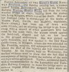
The bridge in the background of the picture seems unlikely to have been for cattle, if only because it isn't wide enough to be useful as one. As confirmation, we have this newspaper article from the Manchester Courier and Lancashire General Advertiser of May 11th, 1850. The bridge is said to connect with Long Millgate, which fits in with any sensible comparison between the photograph and contemporary maps, and it was obviously used for pedestrians. Not only that but as originally constructed, it seems unlikely that it would have withstood the passage of cattle, having only a low handrail over which a person could fall. And that proves that the built up sides of the bridge in the photograph are later additions, post-1850.

I have swapped messages on Facebook with someone who seems to have studied the area around Victoria station extensively and he concluded that the bridge was provided soon after the opening of the station because access along Mill Gate was wholely inadequate. As the river was culverted, and the steep banks were built up, the bridge was retained as a temporary point of access and I believe he said that the point where the bridge ran over the river can be seen in the shape of a bricked-up archway in the wall of the culvert. Once it could be dispensed with, it was, but a section of the bridge was cut out and used to form the present bridge over the river. So the bridge is mainly mid 19th century and has almost certainly been moved from its original location.

And it was never a cattle bridge.
 

Attachments

  • cattlebridge.jpg
    cattlebridge.jpg
    127 KB · Views: 27

Who has read this thread (Total: 207) View details

Top