real time web analytics
Report - - More Misc London Drainz 2020 / 2021 | UK Draining Forum | 28DaysLater.co.uk

Report - More Misc London Drainz 2020 / 2021

Hide this ad by donating or subscribing !

tallginge

more tall than ginger tho.....
Regular User
Rather than updating several drain reports at once I thought I'd just create a new one with lots of bits and bobs from various parts of north and south London. You might recognize some of the areas as I've been to them before but things change over the course of a few years. New camera techniques got learnt, flow levels and penny's dropped, etc.

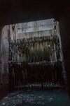
THE Devils Gate (finally) - downstream / pumping station end

DSC06787.jpg


DSC06792.jpg


?hash=af8f06c17417f92268023ddd8ff77888.jpg
DSC06796.jpg


From within the Low Level No.1 just downstream from the "nice" carrier pipe bridge thing. Openings this size would have served a purpose being right next to a pumping station but they now look disused

DSC06806.jpg


DSC06808.jpg


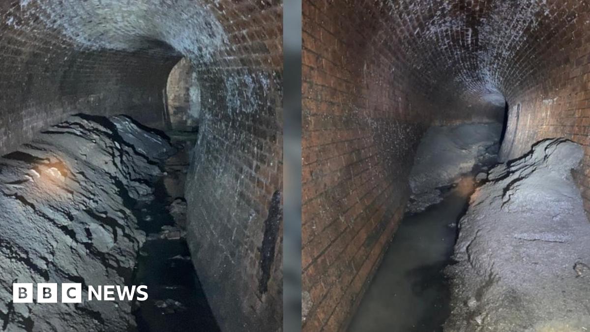
Back in the storm relief- a recognisable photo looking in the opposite direction?

DSC06822.jpg


Upstream end by overflow from Low Level No.2. Tryna make sense of some of the LMA drawings as the overflow used to be very different

DSC06836.jpg


DSC06827.jpg


DSC06826.jpg


Downstream End of Lucky Charms

Plenty of explorers have been to the nice part of this drain but few (as in none - probably lol) have been psyched enough to walk nearly two miles of awkward brick egg to see what happens at the other end. The overflow from the Low Level has seen some changes over the years hence the different bricks. The Yellow Gault Bricks are the original ones. In the first pic i'm crouched in the square overflow pipe which is about 2ft above the live flow. The next one is from the other side of the Low Level looking back across to the overflow. The others show where the Low Level overflow heads towards and then joins the overflow from Lucky Charms close to the Thames

DSC06913.jpg


DSC02117 resized.jpg


DSC06911.jpg


DSC06909.jpg


There's probably another chamber behind these flaps, then the Thames

DSC06899.jpg


The High Level at the upstream end of the storm relief is really silty and easier to splash about in than you'd think. There's another chamber with the penstock in just downstream. This is accessible with care but is very confined and not especially interesting

DSC02138 resized.jpg


DSC02133 resized.jpg


A Local Sewer connection to Low Level No.1 and its overflow between Lots Rd and Western Pumping Stations, north of the Thames. You can hear the tumbling bay roar from the street.

DSC07018.JPG


DSC07019.JPG


Fresh..... from da pumps

There's not many places you can do this in London and even in the small hours it was hands and feet drainin. I stayed upright, just

DSC00249.jpg


DSC00257.jpg


DSC00261.jpg


DSC00264.jpg


DSC00265.jpg


Backward overflow to Low Level No.1 from two local sewers - looking downstream

DSC00273.jpg


DSC00270.jpg


Hammersmith Pumps - Serpants Lair - didn't get a proper look at these last time.

DSC09003.jpg


DSC09011.jpg


DSC08999 resized.JPG
 

Attachments

  • DSC06793 resized.jpg
    DSC06793 resized.jpg
    135.3 KB · Views: 50
  • ?hash=af8f06c17417f92268023ddd8ff77888.jpg
    ?hash=af8f06c17417f92268023ddd8ff77888.jpg
    135.3 KB · Views: 254
Last edited by a moderator:

tallginge

more tall than ginger tho.....
Regular User
Low Level Relief

The Isle of Dogs branch used to join the main Low Level No.1 here until repeated flooding in the area meant alterations were needed as described below. Given that it’s directly beneath the A12 access was a right sod – never again!

DSC06162 resized.jpg


The most important of the works carried out by the council is perhaps that of preventing flooding in the east end of London notably in Limehouse Poplar and the Isle of Dogs As originally constructed what was known as the Isle of Dogs branch which joined the northern low level sewer near Bromley station was 5 feet in diameter with a gradient of 1 in 5,000 The inverts of the main sewer and of the branch were at the same level and upon the occurrence of heavy rainfall when the lowlevel sewer became surcharged the sewage backed up into the districts referred to through the branch It was determined therefore to deal separately with that part of the district for which purpose a new pumping station was erected at Abbey Mills The low level sewer was duplicated between that station and the Isle of Dogs branch but at a lower level so as to give a free discharge to the sewer which was then disconnected from the northern low level The new sewer is 9 feet in diameter and about three fourths of a mile in length and it has proved effectual in preventing the flooding which was formerly so frequent Since it came into operation not a single complaint has been received This work has also resulted in a large addition to the pumping power available at Abbey Mills as the new pumping machinery at that station is capable of lifting 36,000,000 gallons per day to an average height of 40 feet so that not only are the districts referred to relieved but more power is available for dealing with the sewage delivered at the Abbey Mills station by the northern low level sewer

A newer Isle of Dogs Branch has intercepted the old 5ft branch making all the penstocks redundant now.

DSC06174 resized.jpg


DSC06175 resized.jpg


DSC06171 resized.jpg


DSC06168 resized.jpg


DSC06167 resized.jpg


Isle of Dogs overflow.

Because of the early problems with the Isle of Dogs branch not being able to drain away when the Low Level was running full bore an overflow and pumping station were built so even if the tide was in some relief could be afforded. This was the first storm water pumping station that the Metropolitan Board of Works built and one of the first significant upgrades to what was still a fairly new London Drainage system. There now appears to be two overflow pipes. The one on the left (below) went to the first (early) pumping station then when that was decommissioned, they built another pipe to the new pumping station. I went down both pipes but didn’t take pics as nothing interesting happens – the pipes just soon get smaller with a few 6 inch connections. The pipe to the newer pumping station eventually sumps. The concrete pipes enter from the south and the west. North and downstream beneath the mostly obscured penstock is the Isle of Dogs Egg

DSC03296 resized.jpg


DSC03289 resized.jpg


DSC03300 resized.jpg


DSC03308 resized.jpg


DSC03294 resized.jpg


Isle of Dogs Egg

Some of you may have stumbled across this earlier in the year.

TW have been cleaning fatburgs again. The size of this one wasn't measured in African Elephants, double decker buses, swimming pools or boxes of cornflakes though, oh no. One whole bungalow's worth of fat, this time, was removed from a few sewers on different levels. Their last photo surprised me. What's a 10ft brick egg doing upstream of the 5ft pipe that used to be the only drain outta the Isle of Dogs? I still don't know why it was built that size. It's kinda complicated to describe what goes on here but I'll have a go.
A dead end 5ft re-inverted pipe with 6 inch pipe coming in (so not a dead end technically) which is shown on first two pics of link above. Probably a kitchen, lounge and bathrooms-worth of fat blasted downstream of a hole in the invert. Flow from 6 inch pipe goes through relined 5ft dead end pipe and down the hole. Fat and silt remain beyond hole and likely will forever more. After a short distance but a lot of physical effort the pipe stops and any remaining flow goes down another hole besides which are some ladders. I shoulda taken pics i guess but couldn't be bothered.
At the bottom of the ladders is the 3m egg. Flow here is at (my) knee height now that a dining room and one or two bedrooms worth of fat has been removed from the pipe. Walk upstream (beneath pipe above) for a few hundred meters to a 5ft connection from the right with flow coming from south end of Isle of Dogs and the overflow / pumping station, etc. Past the connection the egg continues a short distance further. Flow from above "hole" enters the pipe with a splash and just beyond it the 3m egg also stops abruptly at a dead end.
Turning around I walked back passed the ladders from the pipe above and arrived at a feature worth getting the camera out for

The three 4ft pipes are all local things. The one with the most in comes from the west side of the Isle of Dogs. Walking downstream towards a deafening roar one has to be careful. The flow has been intercepted and sounds like it drops a long way into a modern pipe......I couldn't get by anyway and I wasn't gonna jump the gap. The original egg carried on though and I could see that its flow had been reversed. In other words it would've once carried a lot of flow away from me but now just carries a small amount back towards where it's been intercepted

DSC00085-Pano.jpg


Ratcliff Relief split beneath District Line / Hammersmith and City Line (rate faff that pic was to set up!) and a nearby branch that was too stoopy to bother with last time

DSC09048-Pano.jpg


DSC09078-Pano.jpg


Bastard Crawl to ladders and overflow shaft

DSC09031.jpg


DSC09022.jpg


Then pipe changes to 7ft egg (similar to upstream of Ratcliff split, which is odd) then back to silted up 5ft which leads to Ratcliff Relief main line.

DSC09033.jpg


Tideway have been doing some work at the downstream end of the Ratcliff to divert flow in to the Low Level No.2 rather than out to the Thames - the only works that I can think of that has nothing to do with their Super Sewer. They've removed an enormous flap valve, reversed the last 50m to fall away from the Thames by lining the old brick pipe with concrete and they've fitted a penstock (I think it is anyway) in front of the new weird duck valve things that @TheVicar and i saw previously. Pics from this visit were handheld and not very good - soz!

_DSC1739 resized.jpg


DSC09101 resized.JPG


DSC09102 resized.JPG


DSC09097 resized.JPG


DSC09098 resized.JPG


_DSC1748.JPG


The Pill (aka High Level to Mid Level no.2 Relief) is an overflow from the Northern High Level that used to go to the Mid Level No.2 interceptor. One Interceptor relieving another is really just pushing the problem of vast quantities of run off elsewhere so they completely cut it off from the Mid Level No.2 by dropping it down a tumbling bay and extended it to join The North East Storm Relief (aka Deep Ochre) The old connection is still there, though. Not the most interesting place but if yer don't check yer don't know do yer!

DSC02197 resized.JPG


DSC02194 resized.JPG


Calamity Jane

i see beauty in the unloved, places & things
Regular User
Stunning. Concrete curves, stunning brickwork, grates and hates. Your photos are so inspiring. Never cease to amaze me. Truly stunning stuff. :Not Worthy
 

tallginge

more tall than ginger tho.....
Regular User
Good to see the finer detail of some of these mate, catch up with you soon

Looking forward to it mate :D

Lovely job as usual Ginge! Particularly liking the framing on that Ratcliff split section! Bravo!

Thanks. I realised that processing panoramic photos is quite easy on lightroom and wanted to have a go in a drain. This was one of the first places i thought of as it has a couple of really long, sharp but wide bends and the brickwork is a work of art. On a 14mm lens (F/F) it's 10 photo's stitched together. The original raw file was nearly 200mb! You need several torches as you can't just lightpaint as it'll likely not be even along the join between each pic. The tripod needs to be level as well and that ain't easy in a slippery pipe! It works vertically as well and if yer got the patience it opens up a lot of options.

wow drainage on another level well done :thumb

Thanks. London is another level mate. World class drains!

Stunning. Concrete curves, stunning brickwork, grates and hates. Your photos are so inspiring. Never cease to amaze me. Truly stunning stuff. :Not Worthy

Thanks CJ. It never ceases to surprise me. Just when you think you've seen it all another curious oddity turns up
 

gingerspeedfreak

28DL Full Member
28DL Full Member
Truly impressive and tenacious reporting. How you have fathomed out the layout, flows, connections, interceptions and timelines around changes is amazing. Hats off to you sir!
 

TheVicar

Loyal to the Drain
Regular User
Well this was a nice treat to find on a Monday morning! :thumb
Guess I should look on here more often, especially now we can start getting back to doing things again.

It's good to see that you finally got to Devil's gate in the end after several visits of high waters.
Those upstream pics are interesting, I'm going to have to look on the map to work out where those are :)

Good shots of the downstream end of Lucky Charms, I'll get round to looking at in one day but would rather see the end of Rubix if they ever drain the bugger!

The Isle of Dogs sewer looks suitably repugnant. I bet it's one of those where you feel mucky already after 5 minutes.

Your Panoramas have come out great, The Ratcliff one instantly reminded me of crawling that section on hands and knees. :D
 

tallginge

more tall than ginger tho.....
Regular User
Very interesting that mate. Nicely done!

Thanks mate

Truly impressive and tenacious reporting. How you have fathomed out the layout, flows, connections, interceptions and timelines around changes is amazing. Hats off to you sir!

Thanks. Practice mate and logic ;)

1623765197287.png

1623765255335.png

1623765306056.png


Well this was a nice treat to find on a Monday morning! :thumb
Guess I should look on here more often, especially now we can start getting back to doing things again.

It's good to see that you finally got to Devil's gate in the end after several visits of high waters.
Those upstream pics are interesting, I'm going to have to look on the map to work out where those are :)

Good shots of the downstream end of Lucky Charms, I'll get round to looking at in one day but would rather see the end of Rubix if they ever drain the bugger!

The Isle of Dogs sewer looks suitably repugnant. I bet it's one of those where you feel mucky already after 5 minutes.

Your Panoramas have come out great, The Ratcliff one instantly reminded me of crawling that section on hands and knees. :D

Thanks mate, glad you enjoyed it. Thee and me definitely got to see the better part of Devil's Gate. That gate is BIG though and seeing it like that first time would have saved us a lot of effort eh. Yeah Rubix - should be renamed Nemesis that one - one day! That Isle of Dogs upper section is horrible and sticky - not as bad as TF though :D Glad you like the Ratcliff pano. Think yerself lucky you've only crawled it the once. Backwards and forwards i was adjusting the position/ angle/ brightness of them torches - never again
 

Who has read this thread (Total: 269) View details

Top